Smart exchange and analytics of data
ESRI ArcGIS Pro & ESRI ArcGIS AllSource Plug-in
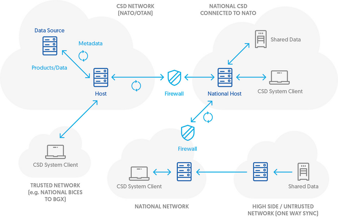
The Coalition Shared Data (CSD) systems enable the rapid sharing of reconnaissance data, i.e. satellite images, reports, maps or drone videos, between parties. The Asseco’s solution is integrated with both Esri's state-of-the-art ArcGIS Pro and ArcGIS AllSource analytical software. As a result, from a single application, military analysts can access the CSD server, search and download the necessary materials, perform analytical work, create a product such as a report and upload it back to the server. Such a solution streamlines work and allows for the ongoing exchange of strategic information within the North Atlantic alliance.
Asseco's solution was positively verified during NATO exercises CWIX 2023, 2024, 2025 and 2026.
CSD EP System Client
Integrates with both Esri ArcGIS Pro and ESRI ArcGIS AllSource – modern analytical software.
Connects to CSD servers from different manufacturers.
Basic and advanced search capabilities, including spatial queries.
AI-powered search: natural language queries, semantic matching, and identification of similar products based on metadata analysis.
Support for standing queries to periodically monitor CSD servers for new products.
Support for GMTI (STANAG 4607) file and stream data, available with UAV platforms such as MQ-9B SkyGuardian.
Support for FMV (STANAG 4609) file and stream data.
Makes possible previewing metadata for products, including data extents on map.
Enables searching and downloading data from CSD servers.
Allows for creating associations, updating metadata and uploading data to CSD servers.
Integrates with the JISR process.
Interoperable sharing of data within the NATO Coalition
CSD EP System Client meets NATO interoperability standards defined by STANAG 4559 Ed. 4
Advanced Search Capabilities
The CSD client allows to search metadata present on CSD servers in the coalition. It is possible to search over every single field defined in STANAG 4559 AEDP-17 and AEDP-18 metadata model and to define spatial and standing queries.


Metadata Discovery
Metadata for all found products can be browsed and footprints for the found products are visible on ArcGIS Pro and ArcGIS AllSource map without downloading any files to local workstation. Metadata related to FMV and GMTI data can also be accessed, providing insights for mission planning, situational awareness, and strategic decision-making. AI-powered search allows natural language queries without rigid phrasing. The semantic engine understands the meaning of the query and also finds related and synonymous results.
Simplification of Analytical Workflow
The CSD client makes it possible to automatically download a product from a CSD server and load it in ArcGIS Pro and ArcGIS AllSource project on the local workstation. Whole workflow from the product discovery to analysis can be performed in a single tool.


Intuitive Publish Interface
Besides metadata analysis, the CSD client ensures a seamless user experience when updating existing metadata or creating new products. It automatically populates certain metadata fields using information from attached rasters and GeoPDFs.
Benefits
Operational efficiency:
automates data workflows, reducing manual effort and speeding up analysis.
Scalability and Compliance:
designed to adapt to diverse operational needs while maintaining NATO interoperability.
Enhanced decision-making:
boosts situational awareness.
User-Centric Design:
intuitive interface and customizable settings. Tools for intelligence, surveillance, and reconnaissance missions.
Discover the Benefits of Coalition Shared Data Systems


We are an official partner of Esri

Contact
Interested? Contact us today
Anna Protasowicka
Sales Director Asseco Poland
e-mail: [email protected]
phone: +48 502 737 490